Today was a foggy day here in Newport.
Today's ride took us beneath the Yaquina Bay Bridge. The way it and the traffic disappeared into the fog gave it a surreal appearance.
Looking back from the west, the bridge became a bit more visible.
We continued along the road paralleling the ship canal toward the South Jetty.
One of the earliest cargo vessels to visit Yaquina bay was delivering supplies for, then lieutenant, Phil Sheridan who was in command of a garrison a number of miles east of here. In the late 19th century, jetties were built to make the passage into the bay safer. These pilings are the remains of the railroad that was used to build the jetty. The rocks you see were hauled in by barge and taken out on the trestle where they were dumped into the ocean.
You can barely see the South Jetty in the background. One of the unintended benefits of the jetties was the gradual extension of the beach south of the south jetty further out into the sea. The location from which this photo was taken was nearly a mile into the ocean before their construction. The prevailing current here is toward the north. As it washed sand in from the south, the shoreline was extended further west. This continues today.
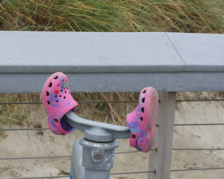
At one time, there were pay-to-view binoculars on this platform. They were removed, but it seems the stanchions still have some functionality. Some mom or dad is wondering where these are....
Looking back toward the East, we can see the dune grass, sea-lyme grass, coastal pine, Sitka spruce, salal, black twinberry, and many other kinds of vegetation that stabilize the newly formed dunes.


No comments:
Post a Comment