Saturday, May 26, 2012

Arches National Park

 From Canyonlands National Park, it is a short drive to Arches National Park.  The entry to the park climbs along a a tall cliff.  This piece of strata balances precariously on a shoulder.
 As does this even more ominous looking boulder.  We don't want to be there when either tumbles.
 Unusual rock formations abound here.  This is Courthouse Towers.
 A short distance away is Balanced Rock.  To give some perspective on the size of this formation; the rock on top has the volume of three school busses and weighs as much as 1600 full sized cars.
 We did not find a name for this formation.  We called the rock to the left, "The Pharoah".
 At Park Avenue three different strata are clearly visible.  The Curtis formation, at the top, is the youngest.  It was deposited as dunes on a beach.  Beneath that is slick rock of the Entrada formation.  It dominates the park and is the stone from which most of the arches are formed.  This was sandstone deposited when the area was a vast desert.  The oldest and softest layer at the bottom is the Carmel formation.  It was deposited when this area was a tidal flat.
Over the millennia, cracks formed and rocks were eroded into these "fins".
 A thick layer of salt, left by the evaporation of ancient seas, liquified under the tremendous pressure of the weight of the overlying rocks.  Often the salt was pushed up into domes.  When fins formed in the rocks that comprised the domes and the salt was washed away, arches were left.  This is the Turret arch.  There are over 2,000 arches in the park.  The smallest is three feet wide.
 Landscape Arch, at 306 feet wide, is the largest in the Park.      
 We drove back to our coach on UT Hwy 128 along the banks of the Colorado River.  The setting sun cast intriguing shadows on the walls of the canyon. The road was windy and there was something unique around every corner.  We even saw a dude ranch and a vineyard. 
As evening fell, we turned onto I-70, drove back to our coach and began a desperate search for superlatives to describe what we had seen.  We found none that were adequate.  Photos are inadequate.  You need to see it for yourself.  How can you see this and not want to learn more about geology?  The teacher, Penny, and the scientist, Ted, wish every student could see this and so much of what we have seen, in person, especially with an experienced guide.  Education would become an adventure.

Tuesday, May 22, 2012

Canyonlands National Park

 It has been two days,but we are still in awe of our visit to Canyonlands National Park.  This park reminded us of the Grand Canyon, but we didn't know about it.  At the first scenic pullout, before we arrived at the Park, we were greeted by this dramatically figured Navajo sandstone bluff.   It was formed from windblown dunes of an ancient desert.  The red color is, of course, a result of oxidized iron.  Layers of less iron rich sediment can also be seen here.   
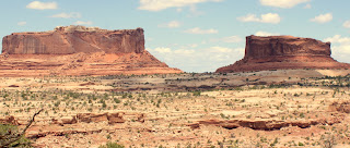
These two mesas, named the  Monitor and the Merrimack are locked in perpetual battle outside the Park.  The Entrada Sandstone cliffs were overlaid atop Navajo Sandstone.
 These filo thin layers of sandstone are deteriorating rapidly (at least in geological terms).
 Much of the road to Canyonlands is open range.  This yearling angus relaxes less than a foot from the roadside.
The spectacular view south from the Schaefer Canyon overlook.
This is the view from the same spot looking toward the North.  The lighter colored line is the Shafer Trail Road.
 Even the view looking up the hill from this spot is interesting.
 Further south,  is the more spectacular Buck Canyon overlook.
 At the end of this road was Grandview Point.  To the left, not easily visible here, is the Colorado River.  To the right, also not easily visible, is the Green River.  To get a bit of perspective on the extent of these canyons, double click on the above image.  The mountains in the distance are thirty-five miles away.
Grizzly bear cacti were abundant and in flower adding to the beauty of the area.  This pink flower variety is somewhat less common than the yellow-flowered variety.

Although we could have spent far longer here, we had scheduled ourselves tightly.  From here, it was on to neighboring Arches National Park.

Monday, May 21, 2012

East on I-70

 As we  headed east on I-70 we ran through increasingly interesting formations along the roadway. 
This area was a part of an ancient sea that repeatedly flooded and dried, leaving layers upon layers of different types of materials.  This area is also rich in fossil beds many dinosaur remains were trapped by one cataclysm or another.  How many different strata can you count in this photo? 
As we ascended, both sides of the road were framed by fascinating cuts revealing past eons.
 Mesas were perched atop slopes littered with fallen of rocks and  boulders.
 Differences in materials deposited are dramatically illustrated here.
 Here, softer lower strata are rapidly deteriorating due to wind and water erosion, freezing and thawing, and the sheer weight of the harder strata above.  Veins of salt have also contributed to forming this landsape.  Billions of years ago this area was covered by salty seas.  They evaporated and reflooded repeatedly leaving layers of salt. Under the pressure, these salt layers behaved like an extremely viscous liquid and was extruded from beneath the heavy overlying rock. In this photo, the rock above is slowly collapsing into the vacated space created as the softer lower layer deteriorates.  Obviously, the process is more complex than this.  
 You can see just about anything you can imagine in the shapes in the rocks and formations here.  This one reminds us of a cupcake with a cherry on top.
 Roadside view areas revealed beautiful vistas, such as  this one. Penny kept gasping, oooing, and aahing. I appreciated her expressing what I was feeling and thinking.  Guess that is one reason we are still married after almost 32 years.
 Don''t you appreciate this dramatically sculpted cliff?  The lone Utah cedar seems almost an exclamation point.
 Smaller beauties such as this pentastamon
 and this Indian paintbrush are easy to overlook in the presence of this grandeur.
 Even this long-dead cedar has its own stark beauty in such a setting.
We ended our day in Green River, Utah looking forward to the next day's adventures.

Sunday, May 20, 2012

Salt Lake City

 After a long, boring drive through southern Idaho, we headed for Salt Lake City.
 As we headed south on I-15, the snowcaps in the distance promised more interesting terrain.
 One can't imagine the forces that thrust heavy rock strata such as these up at this type of angle without feeling a sense of profound awe.
 Salt Lake City is a pretty, clean city framed by the beautiful Wasatch Mountains.  It was also far more urbane than either of us remember from previous trips.
 The buildings and landscaping of Temple Square are always beautiful.
 The Mormon Tabernacle Choir rehearsal chamber is rather impressive isn't it?
 Despite it's less than impressive appearance, this is a fabulous Mexican restaurant.  Their menu features seven different mole' dishes, several offering two different meat choices.  The first night we ate there (this trip), an eighth (mango)mole' served over pork spare ribs was featured.  It was spicy and delicious.  Note the crowd waiting outside for a seat.  This is a light day. 
 This is what we really came for - the LDS Family History Library.  We both spent four days there searching for information to verify or reject geneological leads and identify new ones.  We were both successful on all counts.  Even if you aren't interested in your family history, you have to appreciate the organization of this place, the expertise of the volunteers, and the wealth of original documents.  Ted found the original Christening records for one line of his family in Mexico dated in the early 1800s.
 We left Salt Lake on a rainy morning.  Many of the locals seemed to have a great deal of diffiulty coping  with conditions as we saw two spin outs and almost got hit by two slow mergers - shades of Portland?
After traveling through many miles of construction, we finally cleared the urban area. Almost immediately, the rain stopped and the clouds began to thin.  We left I-15 headed east toward I-70.  We did not know what a treat we had in store.

Saturday, May 12, 2012

On the Road Again

 For the first time in a couple of years, we're taking a road trip to somewhere other than the West Coast.  Needless to say, we're excited.  Here, we're headed east on the Oregon side of the Columbia Gorge.  This is an area we can see from the deck of our house.
 The lush vegetation you see in the previous photo continues for about 80 miles east from Portland to the crest of the Cascade Range.  From there, average annual moisture drops about an inch every couple of miles.  Note that the vegetation here is not as lush, but this only reveals a different type of beauty.
 Ten miles further east, the only trees you see are near the water.
 Water from rapidly melting snow has all of the dams on the lower Columbia open.  This is the John
Day Dam.  Mr. Day was a trapper and hunter engaged to come west with the Astor expedition.  He alledgedly went mad and wandered extensively around the Pacific Northwest in the early 1800s.  He managed to have a dam, a river, a town, and a very rich fossil bed named after him.
 We love this bridge across I-84 in The Dalles, Oregon.  Note the salmon and sturgeon on the railing and the section of a wind turbine beneath.
Ever wonder where Marischino cherries come from?  Many come from this processing facility in The Dalles. Bing and Ranier cherries are brined in these vats until they are nearly white, rinsed, then soaked in sugar water and red dye until they are saturated.
A lot of high grade wheat is raised in the hills above the Columbia Gorge.  It is hauled to elevators like this, loaded into barges, and transported to one of the ports along the lower Columbia River.  From there, seventy to ninety percent is loaded onto grain ships and sent overseas.  Note the RV park and marina in the same space.  Pacific Northwesterners do not waste space, especially if fun can be had.
 The wind is almost always blowing in the Columbia Gorge.  That makes it an excellent place for wind turbines.  These have arisen in the last 4 years.
 There is an increasing number of hybrid poplar plantations in the Umatilla, Oregon area.  Some are used for paper production, but an increasing number are grown for sawtimber.  They are used for such diverse things as molding, Venetian blind slats, wooden pallets, and travel trailer framing (they are 20% lighter than pine lumber).  This is a desert area, but these trees are trickle irrigated and take far less water than the potatoes that are also grown in the area.  An average rotation for sawtimber is twelve to fifteen years.
 This area gets only enough water to raise a wheat crop every other year.  Wheat is often planted in strips to reduce wind erosion.  The areas that appear bare are covered with stubble from wheat that was harvested in 2011 and will be planted again in 2013.
As we climbed out of Pendleton, Oregon, we felt that the scene of the grazing and wheat land below should have been accompanied by strains of God Bless America.  
One of the fun things is always seeing what else is on the road.  Here, a base section of a wind turbine climbs with us.  Many, if not most, of these parts arrive at the Port of Vancouer, Washingon and head east from there.  We see them a lot.
We continued southeast into the lovely Blue Mountains.
 Wheat, canola, and condiment mustard are among the crops grown in the valleys.  The snowcaps in the background give this area near LaGrande, Oregon a very idyllic appearance.
 During the winter, I-84 can be very diffiult as these snow fences indicate.  These are fancier than we have ever seen.
After reveling in the beauty of the Blues and Wallowas, we descended into the Ontario, Oregon/Boise, Idaho area, and began one of the more boring legs of our trek east. However, tomorrow is Mother's Day and we will be in Salt Lake City, UT where Penny (and Ted) will have 4 days to do genealogy at the Family History Library and eat at one of Ted's favorite Mexican restaurants.