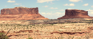
It has been two days,but we are still in awe of our visit to Canyonlands National Park. This park reminded us of the Grand Canyon, but we didn't know about it. At the first scenic pullout, before we arrived at the Park, we were greeted by this dramatically figured Navajo sandstone bluff. It was formed from windblown dunes of an ancient desert. The red color is, of course, a result of oxidized iron. Layers of less iron rich sediment can also be seen here.
These two mesas, named the Monitor and the Merrimack are locked in perpetual battle outside the Park. The Entrada Sandstone cliffs were overlaid atop Navajo Sandstone.
These filo thin layers of sandstone are deteriorating rapidly (at least in geological terms).
Much of the road to Canyonlands is open range. This yearling angus relaxes less than a foot from the roadside.
This is the view from the same spot looking toward the North. The lighter colored line is the Shafer Trail Road.
Even the view looking up the hill from this spot is interesting.
Further south, is the more spectacular Buck Canyon overlook.
At the end of this road was Grandview Point. To the left, not easily visible here, is the Colorado River. To the right, also not easily visible, is the Green River. To get a bit of perspective on the extent of these canyons, double click on the above image. The mountains in the distance are thirty-five miles away.
Grizzly bear cacti were abundant and in flower adding to the beauty of the area. This pink flower variety is somewhat less common than the yellow-flowered variety.
Although we could have spent far longer here, we had scheduled ourselves tightly. From here, it was on to neighboring Arches National Park.
Although we could have spent far longer here, we had scheduled ourselves tightly. From here, it was on to neighboring Arches National Park.


No comments:
Post a Comment